Park Overviews & Directions
- Bank Run
- Battelle Darby Creek
- Blacklick Woods
- Blacklick Woods Golf Course
- Blendon Woods
- Chestnut Ridge
- Clear Creek
- Great Southern
- Glacier Ridge
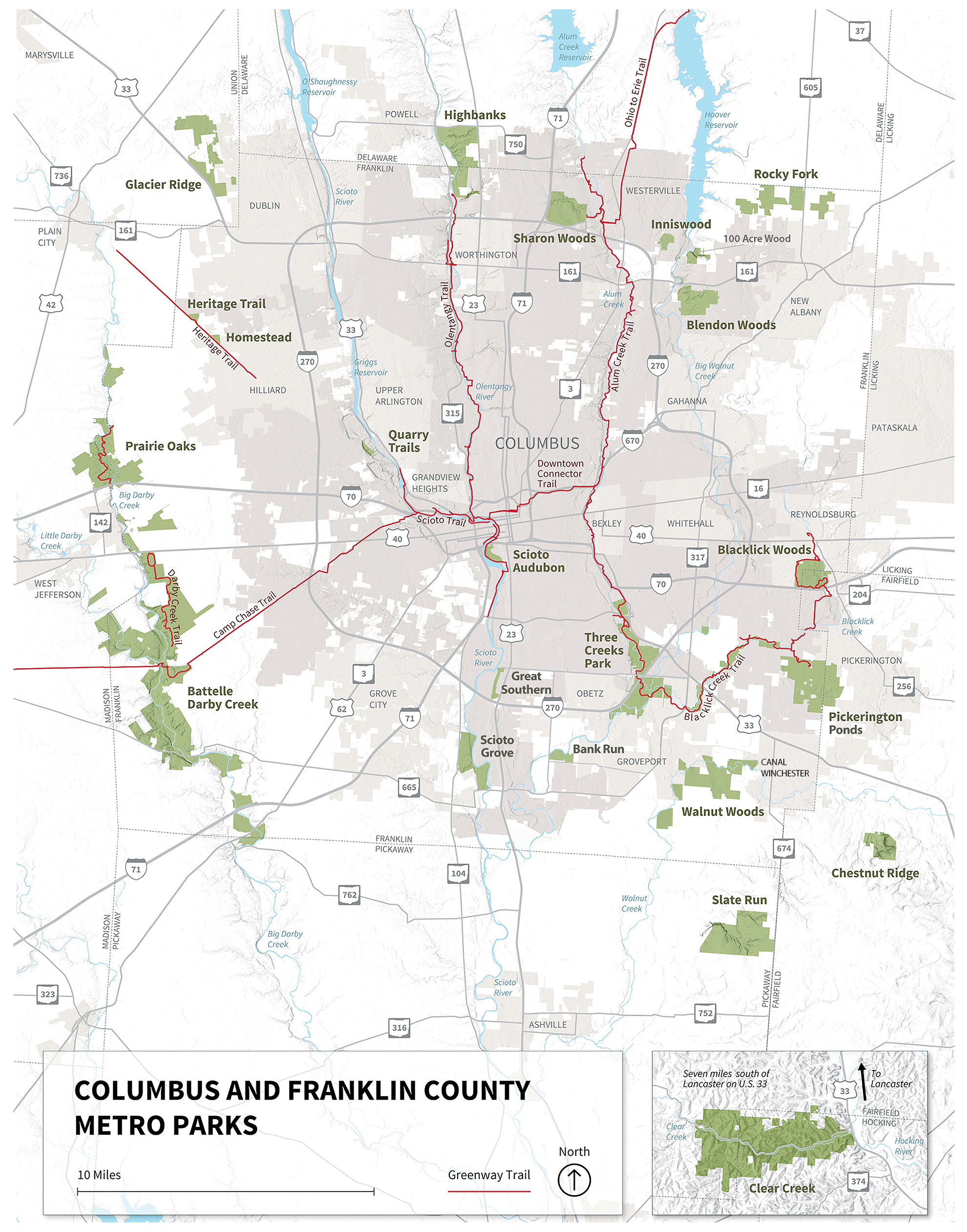
- Greenway Trails
- Heritage Trail Park
- Highbanks
- Homestead
- Inniswood Metro Gardens
- Pickerington Ponds
- Prairie Oaks
- Quarry Trails
- Rocky Fork
- Scioto Audubon
- Scioto Grove
- Sharon Woods
- Slate Run
- Slate Run Farm
- Three Creeks
- Walnut Woods
-
Photo New Vision Media
Bank Run
Columbus, Ohio. Bank Run promises to be a different kind of Metro Park, with its main focus as an event and meeting space. It will be a boon for corporate and large non-profit groups seeking high-capacity facilities for their organizational gatherings. The park has two beautiful lodges, each accommodating 99 people for sit-down functions, plus a newly-built 299-person outdoor shelter. There is also a 3-mile trail which runs around an old quarry lake and into other parts of the park, ideal for large 5K events.
Directions
1570 Rohr Road, Lockbourne, OH 43137
Follow I-270 S to Alum Creek Drive. Take exit 49 from I-270 S. Take exit 49 for Alum Creek Drive toward Obetz. After 0.8 miles, turn right onto Rathmell Road. Go about 1.9 miles and turn left onto Lockbourne Road. Go 1 mile and turn left onto Rohr Road. Park entrance is about 0.6 miles on left.
-
Photo Mac Albin
Battelle Darby Creek
Galloway, Ohio. Battelle Darby Creek features more than 7,000 acres of forest, prairies and wetlands. It stretches along 13 miles of the Big and Little Darby creeks, both State and National Scenic Rivers. Besides the areas surrounding the creeks, there are also over 1,600 acres of restored wetlands and prairies. Bison have been reintroduced to the park and roam freely within two enclosed pastures.
Directions
1775 Darby Creek Drive, Galloway OH 43119
From I-270 take W Broad Street (US 40) exit west. Go about 5 miles on Broad Street to Darby Creek Drive. Turn left onto Darby Creek Drive and go 3 miles to main park entrance on right.
Nature Center
1415 Darby Creek Drive, Galloway OH 43119
Entrance is on right 1 mile before main park entrance. (Indian Ridge Picnic Area is 1 mile south of the main entrance on the right).
-
Photo John Watts
Blacklick Woods
Reynoldsburg, Ohio. Blacklick Woods features 643 acres of woods, fields, seasonal swamp ponds, a small prairie and a golf course. It has one of the best remaining beech-maple forests in central Ohio along with a buttonbush swamp. The forest areas are laced with trails that wind through a swamp forest with oaks, red maple, elm, shagbark, bitternut hickory and dogwood.
Directions
6975 & 7309 E Livingston Ave, Reynoldsburg OH 43068
From I-270, take the E Main Street/Reynoldsburg exit. Go east on Main Street to Brice Road and turn right. Take Brice Road to Livingston Avenue and turn left. Entrance is about 1.5 miles on the right. Golf course is quarter of a mile beyond the park entrance.
-
Photo Craig Gordon
Blendon Woods
Westerville, Ohio. Blendon Woods contains spectacular stream-cut ravines with exposed ripple rock sandstone and open fields surrounded by beech-maple and oak-hickory forests. The 653-acre park is a great place to see a variety of songbirds, waterfowl and other wildlife, especially the flock of wild turkeys meandering about in search of food. The 118-acre Walden Waterfowl Refuge with its 11-acre Thoreau Lake provides a sanctuary for hundreds of birds, ducks and other wildlife. Open year-round, it features two elevated observation shelters with spotting scopes for viewing waterfowl.
Directions
4265 E Dublin-Granville Road, Westerville OH 43081
From I-270, take State Route 161 exit (30B) toward New Albany onto E Dublin-Granville Road. Go 1.6 miles then take the Little Turtle Way exit and turn right. Go to Old SR 161 and turn right. Entrance is half a mile on left.
-
Photo David Jolley
Chestnut Ridge
Carroll, Ohio. Chestnut Ridge is the first ridge in the foothills of the Appalachian Mountains. The ridge spans about 4,500 feet and rises to about 1,116 feet. Black oak, shagbark hickory and northern red oak trees grow on the upper slopes of the ridge and enhance the woodland beauty of the 486-acre park. Sugar maples and American beech are plentiful on the lower slopes.
Directions
8445 Winchester Road NW, Carroll OH 43112
From I-270, take US 33 east toward Lancaster. Go about 11 miles and turn right on Winchester Road. Entrance is about 3 miles on the left.
-
Photo Vincent Frascello
Clear Creek
Rockbridge, Ohio. Clear Creek Metro Park features 5,300 acres of woodland interspersed with blackhand sandstone cliffs, ravines and creeks and is home to more than 2,200 species of plants and animals. Forested areas range from Canadian hemlocks and ferns, to oak and hickory, to Ohio’s last remaining colonies of rhododendron. Home to Ohio’s largest state nature preserve.
Directions
23233 Clear Creek Road, Rockbridge OH 43149
From I-270, take US 33 about 32 miles. Turn right on Clear Creek Road (SR 116). Picnic areas, facilities and trails are located along Clear Creek Road for the next 7 miles.
-
Photo Renata Ramsini
Glacier Ridge
Plain City, Ohio. Glacier Ridge was named for the end moraine or glacial debris left behind when the glaciers retreated some 12,000 to 17,000 years ago. Much of the 1,037-acre park was once covered with farmland. Visitors can traverse a boardwalk through the Honda Wetlands Area or climb a 25-foot observation tower to see waterfowl and other animals.
Directions
9801 Hyland Croy Road, Plain City OH 43064
Take I-270 toward Dublin. Take 33/161 west (exit 17B) toward Marysville. Follow 33/161 west to the 161/Plain City/Post Rd exit. Turn right at the light and then immediately left on Hyland Croy Road. The Honda Wetland Education Area is 1 mile north on the left (7825 Hyland Croy Road). The park’s main entrance is 2 miles further north.
-
Photo New Vision Media
Great Southern
Columbus, Ohio. Great Southern Metro Park opened on April 1, 2026 with a grand celebration and became the 21st Columbus & Franklin County Metro Park. The 70-acre park, bordered by the Scioto River, runs alongside the old riverboat canal land and features prairies, an overlook mound, swing bench, paved and nature trails, fitness stations and an obstacle course. The park also has a playground and recreation field.
Directions
125 Williams Road, Columbus OH 43207
From I-270, take Exit 52A onto US23 N/S High Street. Go 1.1 miles north and turn right onto Williams Road. Park entrance is 0.2 miles on right.
-
Photo Bill Buescher
Greenway Trails
The central Ohio Greenways are multi-use trails used for recreation and alternative transportation. Greenways connect people to the places they live, work and play as well as preserve open space to promote air and water quality. Metro Parks works with several agencies and communities to create and maintain these trails for the citizens of central Ohio.
-
Photo Mark Altmeyer
Heritage Trail Park
Hilliard, Ohio. Heritage Trail features 87 acres and is adjacent to the Heritage Rail Trail, a multi-purpose trail converted from abandoned right-of-way. The 7-mile paved trail starts in Old Hilliard off Main Street and continues toward Plain City.
Directions
7262 Hayden Run Road, Hilliard OH 43026
From I-270 take Tuttle Road and turn left onto Wilcox Road. Turn right onto Hayden Run Road. Entrance is about 2.75 miles on the right.
-
Photo Greg Immel
Highbanks
Lewis Center, Ohio. Highbanks is named for its massive 100-foot-high shale bluff towering over the Olentangy State Scenic River. Tributary streams cutting across the bluff have created a number of deep ravines in the eastern part of the 1,160-acre park. Ohio and Olentangy shales, often containing outstanding large concretions, are exposed on the bluff face and sides of the ravines.
Directions
9466 US 23 N, Lewis Center OH 43035
From I-270, take US 23 North about 3 miles. Entrance is on the left, just before Powell Road.
-
Photo Sarah Hunter
Homestead
Hilliard, Ohio. Homestead is a 44-acre park in Hilliard featuring a covered bridge, a replica train station and an outdoor amphitheater. It has a 0.75-mile paved trail which connects to the 7-mile Heritage Trail, which runs along the park’s western border.
Directions
4675 Cosgray Road, Hilliard OH 43026
Take I-270, turn west onto Cemetery Road toward Hilliard. Go past Main Street and road merges with Scioto Darby Road. Go to Cosgray Road and turn right. Entrance on left.
-
Photo Mary Ann Schell
Inniswood Metro Gardens
Westerville, Ohio. Nestled within a scenic nature preserve, the 121-acre Inniswood Metro Gardens is a source of inspiration for all ages. Streams and woodlands filled with wildflowers and wildlife provide a majestic backdrop to the beautifully landscaped areas. Inniswood boasts more than 2,000 species of plants, specialty collections and several theme gardens. You can support Inniswood Metro Gardens by becoming a member of the Inniswood Garden Society.
Directions
940 S Hempstead Road, Westerville OH 43081
From I-270, take SR 3/Westerville Road exit south to Dempsey Road and turn left. Go about 1 mile to Hempstead Road and turn left. Turn again on Hempstead Road as it jogs right just past the Blendon Township Complex. Entrance is about 100 yards on the right.
-
Photo Ramesh Rangaswamy
Pickerington Ponds
Canal Winchester, Ohio. Pickerington Ponds is a premier spot for birdwatching, with more than 260 species seen. The combination of seasonal ponds and rich wetland vegetation, with bordering woodlands, serve as a magnet for migrating waterfowl, shore birds and land birds. Deer, beaver, fox and other wildlife can be seen near the ponds and adjoining woods and fields of this 1,608 acre park.
Directions
7680 Wright Road, Canal Winchester OH 43110
From I-270, take US33 east toward Lancaster about 3 miles. Take the Canal Winchester/SR674/Gender Road exit. Turn left onto Gender Road, go about 1 mile and turn right onto Wright Road. Go about 1 mile to Bowen Road and turn left. Glacier Knoll picnic and parking area is about a quarter mile on left.
-
Photo Scott Zimmerman
Prairie Oaks
West Jefferson, Ohio. Prairie Oaks features nearly 500 acres of lush flowering prairies and grasslands that were restored using seeds native to the Darby Plains. The spectacular scenery of Big Darby Creek, a State and National Scenic River, which flows through the 2,291-acre park, provides a beautiful backdrop for outdoor adventure along with several deep lakes.
Directions
3225 Plain City-Georgesville Rd West Jefferson, OH 43162
From I-270, take I-70 west to the Plain City- Georgesville Rd/SR 142 exit and go north on SR 142 about 0.8 miles. Entrance on right.
Sycamore Plains Trail
2009 Amity Rd Hilliard, OH 43026
From I-270, take I-70 west to the Plain City-Georgesville Rd/ SR 142 exit and go about 1⁄4 mile south. Turn left on High Free Pike. Go about 1 mile to Roberts Rd, turn left and go about 1 mile. Turn left on Amity Rd.
Darby Bend Lakes
2755 Amity Rd Hilliard, OH 43026
From I-270, take I-70 west to the West Jefferson/Plain City exit, turn right onto Plain City-Georgesville Rd/SR 142. Go about 2.25 miles to Lucas Rd (passing the main park entrance) and turn right. Go across Big Darby Creek, turn right on Amity Road, go about 0.5 miles.
Beaver Lake
8921 Lucas Rd Plain City, OH 43064
From I-270 take I-70 west to West Jefferson/Plain City exit, turn right onto Plain City-Georgesville Rd/SR 142. Go about 2.25 miles to Lucas Rd and turn right. Entrance is about 0.25 miles on right.
-
Photo Larry Hamill
Quarry Trails
Columbus, Ohio. Quarry Trails, the 20th Metro Park, is located within 5 miles of 350,000 residents, fulfilling a need for access to a park in this area and having a Metro Park within 5 miles of every Franklin County resident. Current amenities include trails, observations areas, a single-track mountain bike trail, the via ferrata, the country’s first major urban “iron path,” available by advance registration, a sports climbing wall (bring your own climbing gear), a picturesque 25-foot waterfall and lakes.
Directions
2600 Dublin Road, Columbus OH 43228
From I-270 S, take Exit 10 to Roberts Road and go about 0.9 miles to the park entrance (northern section and mountain bike trail area) on Dublin Road. For waterfall parking lot (2158 Old Dublin Road), go right on Dublin Road to Old Dublin Road and turn left. For Lake Area (2319 Quarry Trails Drive) continue on Dublin Road to Trabue Road and turn left, then left again onto Quarry Trails Drive.
-
Photo Ryan Hill
Rocky Fork
Westerville, Ohio. Features more than 1,000 acres of woods and fields. The park includes a bridle trail, dog park and off-leash dog trail, a paved trail and nature trails plus a picnic shelter and wetlands. Rocky Fork Creek runs through the park, which is a partnership with New Albany, the City of Columbus and Plain Township.
Directions
7180 Walnut Street, Westerville OH 43081
From I-270 take exit 30 to SR 161/New Albany, go 3 miles and take New Albany Road exit, turn left and follow as it veers right on New Albany Road East. Go 0.5 miles and turn left on SR 605 (New Albany-Condit Road). Go 1.4 miles, turn right on East Walnut Street. Entrance 0.7 miles on left.
-
Photo Marshall Reese
Scioto Audubon
Columbus, Ohio. Set amid a former industrial landscape, Scioto Audubon has been transformed from a blighted brownfield into a green oasis where wildlife and birds thrive and flourish. The 119-acre park is a recreational and educational destination for visitors of all ages. Located along the banks of the Scioto River just south of downtown Columbus, the park resulted from a partnership between Metro Parks, City of Columbus and Ohio Audubon to bring nature to the capital city.
Directions
400 W Whittier Street, Columbus OH 43215
From north, use SR315 to I-70 East to the Front Street/High Street exit 100A. (From south, take I-71 to same exit). Turn right on South Front Street, go about 0.6 miles and turn right on West Whittier Street into the park.
-
Photo Matt Evans
Scioto Grove
Grove City, Ohio.Scioto Grove became the 19th Metro Park when it opened in May 2016. The 620-acre park features mature forests and scenic bluffs overlooking the Scioto River. The park has more than 7 miles of trails, two picnic areas with shelters, tables and grills, a kids play area, several overlook decks, and five backpacking sites. Located on a scenic bend of the Scioto River, Scioto Grove is a great destination for canoeists, kayakers, anglers and people wanting to see waterfowl and other wildlife. Dogs on leashes are welcome throughout the park, which also features a kiddies sledding hill and both a regular and 3D archery courses, with giant foam animals as target,. Scioto Grove also has a fine reservable lodge, The Grove.
Directions
5172 Jackson Pike, Grove City OH 43123
From I-71, take Exit 100, Stringtown Road and go east about 1.2 miles. Turn right on OH104/Jackson Pike. Entrance 1.4 miles on left.
-
Photo Dan Ferrin
Slate Run
Canal Winchester, Ohio. Slate Run features a variety of habitats ranging from the open areas of grasslands, wetlands and meadows to the forested areas of beech, oak, hickory and sugar maple. Wildlife viewing opportunities abound at the 1,705-acre park. Sandhill cranes have nested in the 156-acre wetland and the northern bobwhite quail have been reintroduced in the park.
Directions
1375 SR 674 N, Canal Winchester OH 43103
From I-270, take US33 east toward Lancaster to the Canal Winchester/SR 674 exit. Turn right onto Gender Road/SR 674 and go about 2 miles until it dead-ends into Lithopolis Road. Turn left and go about half a mile to SR 674. Turn right and go about 4 miles to the entrance on the right.
-
Photo Julie Heetland
Slate Run Living Historical Farm
Canal Winchester, Ohio. Time has been turned back to the 1880s at Slate Run Living Historical Farm. Experience first-hand what life was like on a 19th-century Ohio farm. As you stroll through the gardens, barns and farmhouse, you will see the farm's costumed staff and volunteers going about their daily chores. Pigs, geese, turkeys, Percheron horses and other heirloom animals can be seen.
Directions
1375 SR 674 N, Canal Winchester OH 43103
From I-270, take US 33 East toward Lancaster to the Canal Winchester/SR 674 exit. Turn right onto Gender Road/SR 674 and go about 2 miles until it dead-ends into Lithopolis Road. Turn left and go about half a mile to SR 674. Turn right and go about 4 miles to the entrance on the right.
-
Photo Carey Sherrill
Three Creeks
Groveport, Ohio. Three Creeks is named for the confluence where Alum, Big Walnut and Blacklick creeks come together. Owls, great blue herons and more than 100 species of birds have been sighted at the park. Visitors may also catch a glimpse of beaver, mink, coyote and deer. The 1,100-acre park is a partnership with the City of Columbus Recreation and Parks Department.
Directions
3860 Bixby Road, Groveport OH 43125
From I-270, take US 33 East towards Lancaster about 1 mile. Turn right on Hamilton Road and go about 1.25 miles to Bixby Road and turn right. Entrance is about 0.75 miles on the right.
-
Photo Tracey Defeyter
Walnut Woods
Groveport, Ohio. Walnut Woods features 1,481 acres of woodlands and fields, bordered by Walnut Creek to the north. The Tall Pines Area features dramatic stands of pines and sweetgum trees, and the Buckeye Area has long rows of old nursery trees such as serviceberry, crab apple and red maples. The park also features restored wetlands and vernal pools.
Directions
6723 Lithopolis Road, Groveport OH 43125
From I-270, take US 33 East toward Lancaster. Go about 1.3 miles then turn right on Hamilton Road/SR 317. Go 2.7 miles and turn left onto Main Street/Groveport Road.
Buckeye Area
6716 Lithopolis Road, Groveport OH 43125
Go 2 miles to Lithopolis Road and turn right. Entrance is 0.75 miles on left. Park office is across the road at 6723 Lithopolis Road.
Tall Pines Area
6833 Richardson Road, Groveport OH 43125
Go 1.4 miles to Richardson Road and turn right. Entrance is about 1.1 miles on right.