VIRGINIA GORDON
Communications Coordinator
In this month’s 20 IN 22 journey through the parks and their history we encounter the kettle lakes and wetlands of Pickerington Ponds Metro Park, and the majestic ridge and first foothills of the Appalachian Mountains that became Chestnut Ridge Metro Park.
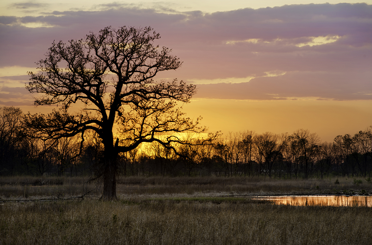
PICKERINGTON PONDS METRO PARK
The wetlands and bordering uplands that would become the core of Pickerington Ponds Metro Park had proven difficult for settlers to tame. It was subject to seasonal flooding, resisted numerous drainage efforts, and was of little value for farming. Fortunately, the area has been preserved in something like its original, natural state, and that makes it really good for wildlife!
The landscape was shaped by the advance and retreat of glaciers in the Winsconsinan Glaciation, which reached its farthest extent in Ohio about 18,000 years ago. It formed a depressed wetland area about three-quarters of a mile long and more than a third of a mile wide. A natural dam was formed to the south by higher glacial deposits, which became partly wooded and partly open, allowing seasonally flooded marshes in an otherwise upland area. In the 19th century, much of the land was owned by two families, the Wrights and the Bowens, whose names are attached to roads that dissect the area. Bowen Road was raised because of regular flooding, and created another effective dam, enclosing the wetlands east of Bowen Road and south of Wright Road. The Bowen family donated land for a school in 1849, and the subsequently named Schoolhouse Road (an extension of Bowen Road), forms the southern and eastern boundaries of the wetlands.
The area became known for its wildlife, especially birds. Guests would stop on Wright Road and Bowen Road to view the large number of bird species that frequented the wetlands. In 1976, former Metro Parks Naturalist and Columbus Dispatch “Nature” columnist, Jim Fry, published his own list of bird species he had seen personally at the wetlands over the previous decade. There were 166 different bird species on his list, many of them rare for Central Ohio. The area was becoming acknowledged as a prime birdwatching site, and went by different names, including Messanger Swamp, Wright Road Ponds or Pickerington Marsh.
Discussions began amongst conservationists, naturalists, and birdwatchers about the unique qualities of the wetlands and about the potential threat to their continued existence because of the expansion of Columbus and suburbs. It was believed that the wetlands could only be saved by taking them into public ownership. A group of committed citizens formed the Pickerington Ponds Committee, Ohio Chapter, The Nature Conservancy, with an objective to help raise the money to buy the wetlands and the adjacent uplands. Major contributors included The Columbus Foundation, the Jeffrey family, the Schumacher Foundation, Wolfe Associates, and the Columbus Audubon Society. Metro Parks contributed about half of the total project funding, utilizing its own budgets and grants from the Ohio Department of Natural Resources.
It was agreed that something like 400 acres would need to be acquired for public ownership in order to preserve the necessary ecological balance of the wetlands. Arrangements were made for Metro Parks to manage the acquired lands as a nature preserve, available for observations and scientific study, with the intention that it should eventually become a Metro Park. (See map of Pickerington Ponds below, with the original 413-acre Metro Park, as it opened in 1989, highlighted over the rest of the now 1,608-acre park).
![]() The first plot of land acquired by the Nature Conservancy Committee, and deeded to Metro Parks, included a feature that is very rare in Central Ohio—a remnant glacial kettle lake. Glacial kettle lakes are formed when large icebergs are calved from a retreating glacier. The weight of the iceberg depresses the soft ground beneath and melt water eventually forms the lake. Most such glacial features have been filled-in, lost or transformed in the thousands of years since the Winsconsin Glacier left Ohio about 12,000 years ago. But the kettle lake in the Pickerington Marsh area remained. To honor the commitment and dedication of the chairman of the Nature Conservancy’s Pickerington Ponds Committee—Columbus attorney William W. Ellis Jr.—the glacial lake was named Ellis Pond.
The first plot of land acquired by the Nature Conservancy Committee, and deeded to Metro Parks, included a feature that is very rare in Central Ohio—a remnant glacial kettle lake. Glacial kettle lakes are formed when large icebergs are calved from a retreating glacier. The weight of the iceberg depresses the soft ground beneath and melt water eventually forms the lake. Most such glacial features have been filled-in, lost or transformed in the thousands of years since the Winsconsin Glacier left Ohio about 12,000 years ago. But the kettle lake in the Pickerington Marsh area remained. To honor the commitment and dedication of the chairman of the Nature Conservancy’s Pickerington Ponds Committee—Columbus attorney William W. Ellis Jr.—the glacial lake was named Ellis Pond.
This first land purchase, of 126 acres, was acquired in November 1979. Another 106 acres was purchased in March 1982, and separate parcels of 68 acres and 57 acres were secured in November and December 1984 for what was at the time known as Pickerington Ponds: Wetland Wildlife Refuge. The Metro Parks Board of Park Commissioners drew up articles of dedication to have the Wetland Wildlife Refuge designated as a state nature preserve. In December 1988, two more parcels were added, of 47 acres and 9 acres, bringing the total to 413 acres. The following year, the Wetland Wildlife Refuge was formally opened to the public as Pickerington Ponds Metro Park.
Bowen Road ran through the marshes and the western edge of Ellis Pond and traffic led to large amounts of sediments and pollutants in the lake. The road also had subsidence issues relating to muskrat burrows, and several sharp curves in the road made it a dangerous place for birdwatchers. Agreements were made to remove a section of the road and rebuild it so it ran west of Ellis Pond. When this was accomplished, Metro Parks built a parking lot, restrooms and a viewing deck off the new Bowen Road section. It became known, collectively, as the Ellis Pond Viewing Area.
A mural, assembled from numerous colorful ceramic tiles, was erected on the Ellis Pond Viewing Area site in 1993 and delights guests even today. Second and third grade students from Pickerington Elementary School, guided by art teacher Mary Sheridan and children’s book author Ron Hershey, created the tiles, reflecting their impressions of animals and plants seen at the Ponds during school field trips over the preceding year.
In the late 1990s, proposals for housing developments and zoning changes in the area led to public disquiet about potential damage to water quality, and to the impact on wetlands and wildlife in the new park. An engineering report concluded that storm water runoff from the proposed housing development could pollute the wetlands and also contaminate municipal water supplies. It led to petitions and compromises in the development plan, and to a significant increase in land holdings by Metro Parks, to protect the wider wetland watershed.
A grant of $745,000 was obtained from the Natural Resources Conservation Service, part of the United States Department of Agriculture, for a 370-acre wetland restoration project that led to the creation of Arrowhead Marsh and the Glacier Knoll Picnic and Viewing Area. The project converted old crop fields to wetlands and grasslands by the destruction or removal of buried drainage tiles, the construction of berms and mass planting of native flora. The Glacier Knoll Area opened officially with a grand celebration and dedication ceremony on June 13, 2004.
Overall, Metro Parks has restored almost 750 acres of wetlands and adjacent habitats in the expanded park area since 2002. Much of the funding has been obtained through grants from the Ohio Environmental Protection Agency’s Water Resource Restoration Sponsor Program (WRRSP). The goal of the program is to counter the loss of ecological function and biological diversity that jeopardize the health of Ohio’s water resources. The program funds projects that specifically target the protection and restoration of high-quality streams and wetlands.
More than 260 species of birds have now been recorded at the 1,608-acre Pickerington Ponds Metro Park. The Audubon Society has designated Pickerington Ponds as one of its IBAs (Important Bird Areas). Metro Parks has built trails and observation decks so that park guests can get closer than ever to the wildlife that inhabits this wonderful natural resource. A heron rookery was established on the south side of Ellis Pond, while rare species such as glossy ibis, American avocet, marbled godwit, surf scoter and the American white pelican have delighted birdwatchers with their presence at the ponds.
In the late 2000s Metro Parks acquired some additional lands on the western edge of the park, which carried our land holdings as far west as Gender Road. After a lot of restoration work and park planning, these lands were opened as the new 213-acre Burning Lake Area on March 5, 2022. Burning Lake has its own entrance on Gender Road and features a 1.5-mile loop trail that takes guests through wildflower fields and a small woodland, and around wetlands and lakes. There are also plans for a natural play area at one of the ponds. The name, Burning Lake, refers to an oral record of a fire that started when the marshes dried out sufficiently for underground peat to ignite. The fire smoldered for days and suffused the area with smoke.
MAP OF PICKERINGTON PONDS METRO PARK
*
CHESTNUT RIDGE METRO PARK
On March 7, 1962, the Metro Parks board announced plans to purchase land in an area of Fairfield County known as Chestnut Ridge. It was an attempt to preserve land from the attentions of developers, who intended to create a residential housing development that was to be called Chestnut Heights. The purchases by Metro Parks were to include some existing homes, and also a number of orchards, which had been established on the “ridge” in the mid-19th century.
As quoted in the Columbus Dispatch, on March 7, 1962, Metro Parks’ Director-Secretary Walter A. Tucker said that “The park board has long regarded Chestnut Ridge as a highly desirable site for a park and scenic overlook.” It was yet another example of forward-thinking by an organization fighting to conserve natural landscapes in the face of the ever-growing creep of city and suburbs. The Ridge itself was already highly regarded by nature lovers. “Nature Notes” columnist, Charles Goslin, writing for the Lancaster Eagle Gazette in his column of November 1956, waxed lyrical about the Ridge, its rocks and its trees. But while acknowledging the prevalence of native trees that grew here, such as beech, sugar maple, chestnut oak, basswood and dogwood, Goslin also acknowledged that there were many orchards on the Ridge, that he and his fellow hikers felt uncomfortable walking through.
Goslin also wrote about the geology of the Ridge, principally Black Hand Sandstone, and an old quarry on the site, from which huge blocks of sandstone had been hewed way back in the 1830s, and had gone towards the building of seven locks on the Carroll to Lockville stretch of the Ohio Erie and Hocking Canals. The main quarry was in the northern part of the park, east of Amanda Northern Road. When the railroads replaced canals as the premier means of industrial traffic, little more than 40 years after the creation of the canals, quarrying on the site gradually ceased, and it reverted to second-growth forest. Today, a profusion of trees, including big sycamores, sugar maples and black cherry trees dominate the old quarry pits.
Metro Parks feared that public access to the Ridge would have been lost if the Chestnut Heights housing development had happened. Although some funds were available for land acquisition, there was little money available in those years for full park development and it would be more than 25 years in the future before the park would be ready to open. Aerial surveys were conducted to establish the definite size and location of the future park and land purchases began in April 1962.
By the end of that year, Metro Parks had acquired seven parcels of land on the ridge, totaling 81 acres. Five years later, by early 1967, most of the land that would become the future Chestnut Ridge Metro Park was owned by the park district. The Ridge rose to a high point of 1,116 feet above sea level. It was part of the Allegheny Plateau or Escarpment, and also considered, by some, as one of the first foothills of the Appalachian Mountains. In those early years of land ownership, Metro Parks resource managers removed many of the apple trees and allowed natural succession to play a part in restoring the Ridge to its natural woodland state.
While living on the north slope of Chestnut Ridge between 1975 and 1977, author David Rains Wallace kept a journal, which formed the basis of his book “Idle Weeds: The Life of an Ohio Sandstone Ridge.” In the book, he wrote, “The abiding value of the ridge is in its small part in the fundamentally wild process that sustains life. The fact that there are still thousands of ‘idle’ or gently used places like it engaged in cycling water, minerals and gases through the biosphere is what give Chestnut Ridge its main significance.”
In July 1977, as part of a Capital Improvements Plan for the 12 years ahead, 1978 to 1990, Metro Parks committed to a budget of around two and a half million dollars to create the necessary infrastructure and features to open Chestnut Ridge Metro Park. As part of the plan, one more essential land purchase was needed, to form the main entrance to the park. Acquired in 1980, this 37-acre tract brought the total acreage of the park up to today’s 486 acres. A 2-acre pond and a wetland were created in this area, with a parking lot, restroom, picnic areas, and access to trails that would allow guests to traverse the Ridge. At the height of the Ridge, on the 1-mile Ridge Trail, an observation deck was built, from which guests, on a clear day, can get a remarkable view of the Columbus city skyline, about 19 miles away. Another 1-mile trail, the Meadows Trail, runs through woodland on the southern sector of the park. Both trails are connected by the 0.4-mile Homesite Trail, which includes the foundations of some of the homes that existed here in the days when the orchards plied their trade and supplied Columbus and other surrounding towns with fresh, locally-grown fruit.
All of these park features are on the eastern side of Amanda Northern Road, which more or less dissects the park into two sections, east and west. In mid-December 1988, Chestnut Ridge Metro Park finally opened to guests, but on weekends only. In January 1989, the first public naturalist-led program was held here. And finally, on May 29, 1990, the park opened full-time.
There was a lot of debate about what to do with the western section of the park, on the west side of Amanda Northern Road. It was recognized that the road created a strong barrier between the two sections of land, and there had even been a suggestion, made in a development survey, commissioned in 1980, that the road should be removed and the land be allowed to revert to its natural state. That never happened, and the western section of the park remained closed to guests for many years. Then in 2010 the Central Ohio Mountain Biking Organization (COMBO) approached Metro Parks for discussions about the potential for building a mountain bike trail here. Agreements were made, and under Metro Parks supervision, volunteers from COMBO worked tirelessly to create a singletrack, 9-mile Mountain Bike Trail. The Mountain Bike Trail opened officially on Saturday October 16, 2011. A gravity/flow trail, for expert riders, was added in 2016. Metro Parks Park Rangers make the decision as to whether the trail is safe to open, based on weather conditions.
This western section of the park is also the site of a Native American Mound that has been registered on the National Park Service’s National Register of Historic Places. Old Maid’s Orchard Mound, close to an old apple barn just west of Amanda Northern Road, was nominated for inclusion on the register in 1972 by the Ohio Historical Society, and accepted as a Historic Place of local interest. The mound is believed to be a relic of the Early Woodland People, also known to us as the Adena, and stands 8-feet high, with a diameter of around 75 feet.
The name of Chestnut Ridge reflects the historical fact that American chestnuts grew profusely on the ridge in times past. The blight that virtually wiped out the American chestnut tree was first spotted in New York at the beginning of the 20th century. It’s believed that the chestnut blight (a parasitic fungus) arrived there with the importation of Chinese chestnut trees. By the 1950s, all the chestnut trees on the Ridge had died from the blight. New plantings of American chestnut trees would survive for only five to ten years before they succumbed also to the disease.
Ironically, the Chinese trees that carried the blight, also carried their own immunity to the fungus. A few experiments have been made at Chestnut Ridge to create hybrid versions of chestnut trees, using 90 percent American chestnut tree genetics with about 10 percent of the Chinese chestnut tree genetics. A few of these trees have survived beyond 10 years without showing any signs of the canker that the blight causes. It’s far too early to claim success, but it leaves hope that at some point in the future, Chestnut Ridge may once again be known and admired for its chestnut trees.
MAP OF CHESTNUT RIDGE METRO PARK
*
As our 20 IN 22 series continues, next month we’ll take a look at the largest Metro Park, Battelle Darby Creek. Stay tuned and see you at Metro Parks!
Wow. Really nice write-ups!
A question: At Pickerington Ponds, just to the east of the Arrowhead Trail, is a somewhat elevated area. Do you know what formed that? It’s a bit low for a Native American Mound. Might it be a small glacial kame? Or maybe just dirt (or trash) that farmers moved there? Thanks.
Hello Bob, thanks for your comment. Without being on site and seeing exactly what you’re referring to, it’s hard to give a definitive answer. This area was within the larger wetland restoration area, north of the original 413-acre park boundary, as referenced in the article. There were many berms created here as part of those wetland restoration efforts (raised areas to help retain or direct the flow of water). This may be what you are seeing.
Virginia, you can kind of see it in the center of this Google Map: https://www.google.com/maps/@39.885985,-82.7930615,548m/data=!3m1!1e3
It’s north of where that (barely an) access road leaves Wright, and is south from where that ditch from the east joins Georges Creek. In fact, the access road curves around it to the east.
Thanks.
Hello Bob, thanks for the follow up and for sending the Google Earth image. I asked one of our resource managers to come and take a look at the image and we believe that it is a glacial kame. At one time there was a home on this site also.
I have been told there is a kame north of the mural at Ellis Pond. The mound is comprised of aggregate and some soil. I made some great memories at PP.
Thank you again to everybody for looking at this further! I had my suspicions, but I also have a lot of ignorance. 😉 And of course, in such marshy ground, that would be the best place to put a farmhouse.
Thanks again! I feel enlightened.
I have enjoyed hiking at both of these parks. It’s really wonderful to know the history behind them. Thank you so much!
Thank you for continuing to preserve these priceless areas. Our family is in its 12 generation of Ohioans and we appreciate the foresight of the early Metro Parks leadership in preserving these important kettle lake, wetland and Appalachian range areas! Fabulous.
It was a delight to work cooperatively with Metro Parks as a former Franklin County Commissioner.