VIRGINIA GORDON
Communications Coordinator
Following the launch of our 20 IN 22 theme in the January edition of Metro Parks News (20 IN 22: A Multigenerational Celebration of Metro Parks), we now present the first of ten monthly articles, each one focusing a narrower attention on two of the 20 outstanding parks that comprise the Columbus and Franklin County Metropolitan Park District. Today we look at the 11th and 12th parks in the Park District (Three Creeks Park and Prairie Oaks Metro Park), which opened within four years either side of the millennium.
THREE RIVERS BECOMES THREE CREEKS
Three Creeks became the 11th Columbus & Franklin County Metro Park in 1998, but a 410-acre park called Three Rivers Park had existed on site since the early 1970s. The City of Columbus Recreation and Parks Department operated Three Rivers Park on land that encompassed the confluence, or coming together, of the three rivers (creeks, actually), Alum Creek, Blacklick Creek and Big Walnut Creek. In 1981, to mark Columbus being designated as a ‘Tree City USA,’ a long-running initiative from the National Arbor Day Foundation in cooperation with the National Association of State Foresters and the USDA Forest Service, the city planted thousands of trees in Three Rivers Park. Regrettably the majority of these trees were non-native white pines, but it successfully restored a large area of former agricultural land to a woodland setting.
In June 1998, the City of Columbus leased its then 500-acre site to Metro Parks for management and development of what became known as the Three Creeks Park Project. Renamed from Three Rivers Park to Three Creeks Park (note, the official name does not include the word ‘Metro’ although it is often referenced as Three Creeks Metro Park), Metro Parks acquired new land through purchases and easements, for what is now a 1,100-acre park. As part of the partnership agreement, Metro Parks and the City of Columbus set out to clear old dumpsites, build new trails, and share management and operation of the new park entity.
The city manages the Sycamore Fields Area, which has fenced-in dog parks for both large and small dogs, plus four baseball/softball diamonds and seven playing fields for soccer and football. The Smith Farms Area is also maintained by the city’s Recreation and Parks Department. For many years, the city hosted a Fall Harvest Jamboree on site in October, to celebrate the history of Smith’s Famous Farm, a once-thriving vegetable farm. The city refers to its own sections of the park as ‘The Creeks.’
The new Three Creeks Park became one of the major hubs in the Central Ohio Greenways system. Both Metro Parks and the City of Columbus are major partners in the Greenways project, developed by MORPC (the Mid-Ohio Regional Planning Commission) to add Greenway Trails that connect our region’s scenic river corridors with local neighborhoods, parks and attractions.
A MEETING POINT FOR TWO GREENWAY TRAILS
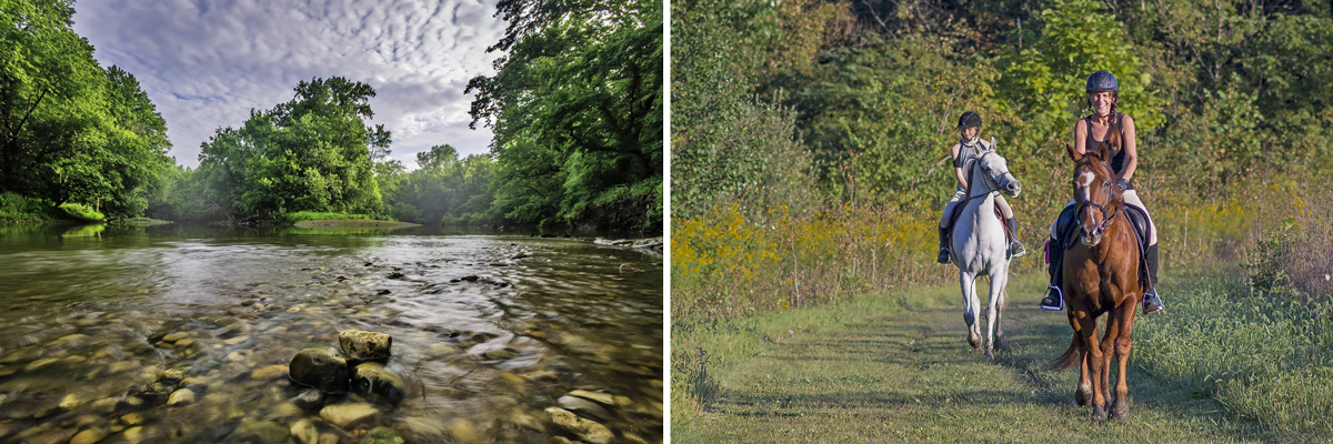
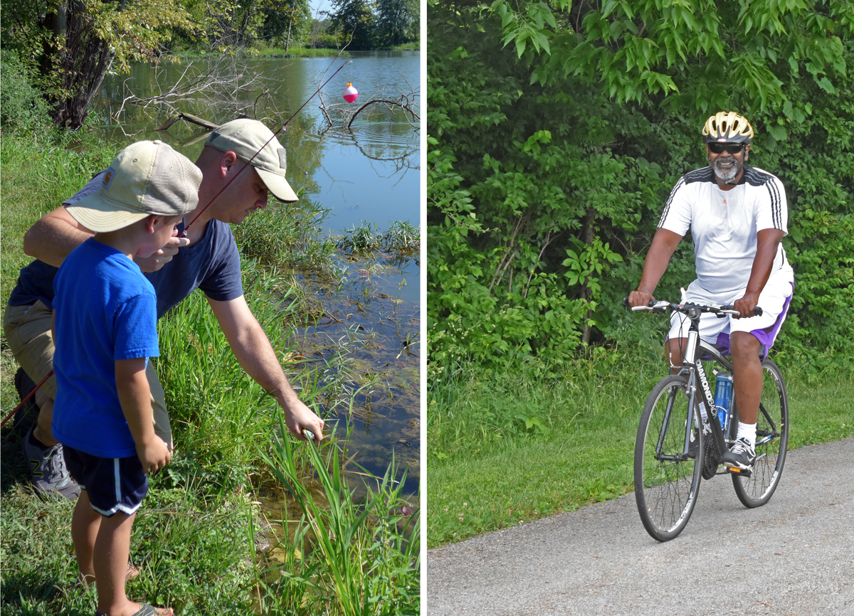
Metro Parks opened the first phase of the Alum Creek Greenway Trail in 1998, running north from Heron Pond, and extended it south from Heron Pond the following year. At that time, the Alum Creek Trail totalled 7.5 miles. The first 2.8-mile section of the Blacklick Creek Greenway Trail was constructed and opened in 2001. Both trails meet and have their start points in the Confluence Trails Area, one of five distinct areas of Three Creeks Park. The Blacklick Creek Greenway Trail has now been extended beyond the park, connecting Three Creeks Park with both Pickerington Ponds and Blacklick Woods Metro Parks, over a length of 16 miles. Meanwhile, the Alum Creek Trail now extends north of Three Creeks Park and terminates at Polaris over a distance of nearly 25 miles. These wide, paved trails are very popular with bikers and they also have plenty of room for hikers, with or without leashed pets.
BORROW PITS BECOME PONDS
The construction of I-270, which intersects the park, had required the creation of borrow pits, taking soil to help in the construction of overpasses and highway interchanges. Some of these pits became ponds, the largest being what became the 10-acre Heron Pond, now an area of scenic beauty at Three Creeks and also a great spot for fishing. Park visitors can fish for bluegill, catfish and largemouth bass. This water-filled borrow pit had been known as Lake Therll before the City of Columbus bought the land. Fishing is also available at nearby Turtle Pond and in any of the three creeks.
BEAUTIFUL NATURE TRAILS YIELD VIEWS OF THE CONFLUENCE
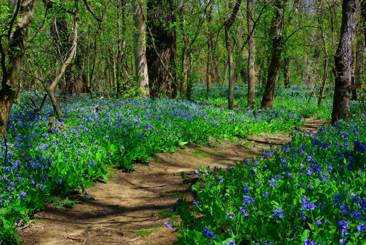
The confluence of the creeks can be viewed by visitors who walk either the Confluence or Bluebell trails. These beautiful nature trails are for hikers only, but the Evergreen Trail is also a natural surface and allows leashed pets. The Evergreen Trail loops around a 12-acre natural play area, where young and old can climb trees, play off-trail or dig in the dirt of a pine forest.
The start points of these three trails, plus the confluence of the three creeks, are contained within the Robert “Tad” Jeffrey Off-Trail Reserve. This 90-acre area was established by the Metro Parks Board of Park Commissioners to honor Mr Jeffrey’s 16 years of service on the board. The area was officially designated at a ceremony at the beginning of May 2016, which also saw the opening of an overlook deck yielding stunning views of the confluence.
The wooded area near the Bluebell and Confluence trails is one of the best mature riparian forests in central Ohio, with many towering cottonwoods and sycamore trees. The woodland and creekside displays of bluebells along the Bluebell Trail, in particular, are a must-see for visitors in April each year.
West of the Alum Creek Trail there are a number of seasonal wetlands that attract shorebirds and waterfowl in migration season. These are amongst more than 100 species of birds recorded at the park.
Aside from the two Greenway Trails that wend their way well beyond the boundaries of the park, Three Creeks boasts 5 miles of trails. Except for the Bluebell and Confluence trails, leashed pets are allowed on all of these trails, and the park also boasts a 4-acre dog park in the Sycamore Fields Area. The dog park is managed by City of Columbus Recreation and Parks.
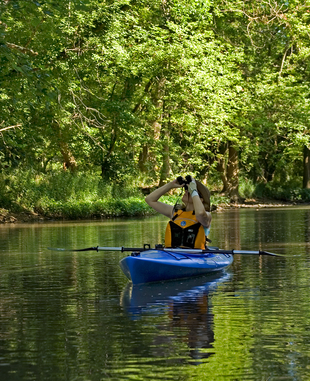
Canoers and kayakers can access Alum Creek at a take-in point just north of Watkins Road and take a leisurely float of about 2 miles to the confluence of the creeks, and continuing on for another 2.75 miles on Big Walnut Creek to the take-out point just north of Grosvenor Road, in the farthest southwest region of the park. The canoe float will take you past the site of the eagle nest, where eagles have nested now for many years, and provides the only good view of the nest from within the park.
*
PRAIRIE OAKS BECOMES THE FIRST METRO PARK OF THE 21st CENTURY
Prairie Oaks, the 12th Metro Park, would become the second park through which Big Darby Creek flowed. Although the official opening of the park would be delayed until 2002, the park district began acquiring land for the future Prairie Oaks Metro Park in 1991. In those early days, long before the park would open, it was referred to internally as Upper Darby Metro Park. Passage of the Metro Parks Levy in May 1999 secured funds to move ahead with development plans. In 2000, a park manager was appointed for the future park, and both she, (the first female park manager in Metro Parks) and the park naturalist at Battelle Darby Creek Metro Park, would lead hikes in Prairie Oaks, along the newly-created Sycamore Plains Trail. The name Prairie Oaks was settled on because of the prairies restored by Metro Parks in the years ahead of the park opening, and because bur oaks had long thrived on the land in large groves. Some of these bur oaks are as much as 7 feet in diameter and provide an impressive sight for visitors.
At that time, the new park extended to just under 1,300 acres. Much of this land had been acquired by the City of Columbus in the 1970s, when the city intended to submerge the area and create a reservoir for Columbus’s and Franklin County’s future drinking water needs. This Upper Darby Dam project attracted widespread opposition from environmental groups and the plan wasn’t fully dropped until 1992.
Ironically, merely the proposal of the Upper Dam Project, and another ultimately rejected flood-control reservoir project, the Lower Dam Project proposed by the US Army Corps of Engineers, had spared the Darby Creek watershed from the attentions of housing and strip mall developers. Their eyes would have been on the area, after the I-70 and I-270 construction in the 60s and 70s created a population swell. But no one builds a strip mall on land that might be 50 feet underwater in times-to-come.
Today, thanks to this combination of good fortune and good management, Prairie Oaks Metro Park has grown steadily and now stands at 2,291 acres. More than two miles of Big Darby Creek flows through the park, which also features some outstanding natural areas that predate European settlement. This includes a 30-acre oak-savanna, a mixture of oak woods and grasses that provides a perfect habitat for grassland bird species. This stand of old-growth trees marks a transition between the old Darby Plains prairies and the forested areas to the east.
To honor the pre-settlement history of the Darby Plains, once a vast wet-prairie ecosystem, Metro Parks has restored 800 acres of prairie at the park, using native seeds hand-collected from tiny remnant prairies. The prairies are a must-see for park visitors in July and August, when the spectacular blooms of royal catchfly and various coneflower and sunflower species produce a riot of color in amongst the tall prairie grasses, such as big and little bluestem.
DARBY BEND LAKES
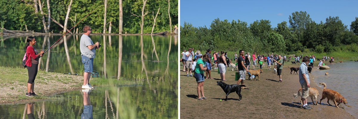
The Darby Bend Lakes area opened in May 2006. It features three large ex-quarry lakes, ideal for various water activities, such as fishing, canoeing and kayaking and non-motorized boating. One of the lakes has its own dog beach where your furry friends can swim with joy. The Darby Bend Lakes area was the center point for the annual Wag!, a festival that brought thousands of four-legged guests and their two-legged handlers to the park every August. In 2024, when the long-time organizers of the festival retired from the project and left it on the point of cancellation, Metro Parks staff took up the reins and organized the first Bark Bash, which didn’t miss a beat or a bark as vendors, visitors, and four-legged furry friends made Prairie Oaks the dog capital of the world for six hours on a single Saturday in August. Bark Bash will continue in 2025 and onwards.
THE LEVEE PROBLEM
Metro Parks had purchased the old Olsen Quarry in 2001, which had operated for decades and was located close to a sharp turn in Big Darby Creek. This quarry became the foundation for the Darby Bend Lakes, and its location along the sharp turn of the creek explains the area’s new name.
In 2007, Metro Parks contracted for a major capital improvement project at Prairie Oaks. The Olsen Corporation had built a levee to protect its quarry from flooding from high water on the creek. But this levee caused problems for the creek itself, leading to extensive erosion of the creek banks.
The project was in part funded by grants from the US Environmental Protection Agency, and involved lowering the 2000-foot-long earthen mound by stripping 5 feet from the top of the levee. The project also included the removal of a 200-foot section of another levee nearby. The result of this major project slowed the flow of water in the creek after heavy rains, which reduced erosion and also contributed to improved water quality in the floodplain.
THE PARK TODAY
Beaver Lake, another ex-quarry lake, is the heart of a 25-acre natural play area. Located in the northernmost part of the park, it is surrounded by the 0.9-mile Beaver Lake Trail, one of 10 trails in Prairie Oaks, totaling more than 17 miles, and including a 5.7-mile Bridle Trail.
The Prairie View and Whispering Oaks picnic areas and the Darby Bend Lakes area have picnic tables, grills and shelters available on a first-come, first-served basis.
Prairie Oaks was the first Metro Park to operate a carry-in, carry-out trash program, providing bags for guests to take away their trash. The success of this program has seen it extended to Walnut Woods, Rocky Fork and Scioto Grove Metro Parks, which all opened in the 2010s.
There are five distinct areas at Prairie Oaks, each with its own entrance and parking lots. Three are on Amity Road, on the eastern side of the park, these being the Upper Darby Canoe Access, Darby Bend Lakes and the Sycamore Plains Area. Beaver Lake is accessed from Lucas Road, which crosses the park east to west, and connects in the west with Plain City-Georgesville Road, on which the main park entrance stands and which gives access to the Whispering Oaks Picnic Area and trailer parking for the park’s 5.7-mile Bridle Trail. The Bridle Trail has a short extension that crosses Big Darby Creek just south of Darby Bend Lakes. It is reserved solely for horse riders, except when snow conditions exist, when cross-country skiing is allowed on the trail.
*
As our 20 IN 22 series continues, next month we’ll take a look at Highbanks and Walnut Woods Metro Parks. Stay tuned and see you at Metro Parks!
Does your Little Turtle-Big Walnut Creek park have a name. And will there be marked trails with blazes and a map of the park? I’m afraid I would get lost in this heavily wooded park.
Hello Tom – I promise you, you won’t get lost. There are brown marker posts to give guests an idea of where to explore. This area of Blendon Woods is called ‘100 Acre Wood’ and it’s a magical area, with pristine forest and streams. You can access this wonderful area from 5220 Cambria Way, Westerville, Ohio. There are some established trails in the area, but you can you make your own way and discover land as it used to be before European settlement of Ohio. The entire area allows leashed pets. There are no current plans for a map of the area, but you can check out this Tim Talks video about our 100 Acre Wood here: https://www.metroparks.net/blog/tim-talks-discover-metro-parks-100-aker-wood/