VIRGINIA GORDON
Communications Coordinator
The creative impulse to found what would eventually become Sharon Woods Metro Park is inextricably linked with plans to build two major Interstate freeways. The preservation or restoration of natural areas was always a guiding principle of the Metro Parks mission, so when plans were developed in the late 1950s for both a freeway connecting Cincinnati, Columbus and Cleveland along the Ohio portion of its route (the future I-71), and for the so-called Columbus Outerbelt, the 55-mile-long loop of I-270, minds were fixed on the possible ramification for an area where the two planned freeways would interconnect – Westerville, Ohio.
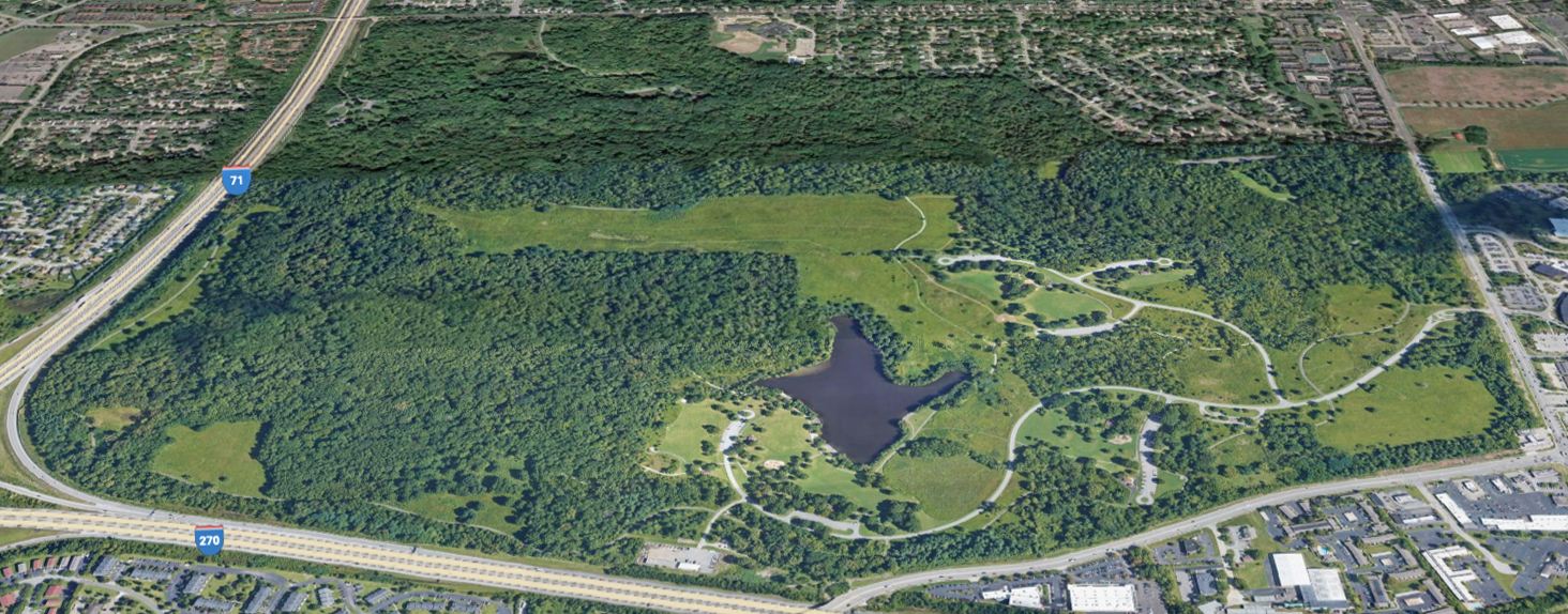
Even a cursory glance at a map of Sharon Woods Metro Parks shows how it is bordered by I-71 to the west and I-270 to the south. The creation of I-270, in particular, was expected to generate massive development and expansion in the area, as indeed happened. Work began on the construction of I-270 in 1962. The section between I-71 and Cleveland Avenue opened officially in November 1966. Parts of I-71 were also established in Ohio in 1962.
In large part because of I-270 and associated town planning developments, the city of Westerville experienced the greatest decade-long population expansions in its history over the following two decades. The citizenry of Westerville increased from 7,011 at the 1960 census, to 22,960 at the 1980 census, a massive rise in population of more than 227 percent.
The foresight of Metro Parks planners ensured that the expanding local citizenry would have a Metro Park in their midst. Protecting open space in the area had become a priority. In February 1962, Metro Parks acquired its first parcel of land in the future Sharon Woods, a 139-acre area in the northwest section. An assertive commitment to further land acquisition led Metro Parks to complete 23 different transactions by August 1965, acquiring land from farmers, private landowners, and even some developers. The boundaries of the future park were more or less fixed by then, and the 762-acre park would finally open in October 1968.
SCHROCK LAKE
Meanwhile, engineers working on construction of the new interstates found themselves in need of huge amounts of soil to grade an interchange between I-71 and I-270 at the southwest corner of the future Sharon Woods. In 1965, they asked Metro Parks for permission to take the needed dirt from park land nearest to the interchange. Metro Parks agreed permission for the engineers to acquire the dirt, but insisted on a location in a more central area of the park. And so, a borrow pit was dug, which became the foundation for the future Schrock Lake. Metro Parks constructed a small dam and spillway, to raise water levels, and shaped the shoreline of the lake with various inlets and coves to create inviting habitat for various species of wildlife.
Cottonwoods, cattails, reeds and willows were planted along certain sections of shoreline to further enhance the appeal to wildlife. The 11-acre Schrock Lake quickly attracted animals, with muskrats discovered to be living in lodges amidst the cattails on the banks, and mink seen swimming in the lake or emerging from the shores. Wood duck nesting boxes were installed in the north end of the lake, along with a large purple martin house. Both were successful in attracting these colorful species to the lake, along with dozens of other species of migratory waterfowl.
CONFERENCE AND EDUCATION FACILITIES OPEN BEFORE THE PARK OPENS
As early as June 1961, Metro Parks had developed a plan for a Conference and Outdoor Education Center, to be located on the land that it hoped to acquire soon in Westerville, and utilizing existing buildings on this, and future land acquisitions at Sharon Woods. And so, the Spring Hollow Outdoor Education and Conference Center came into being. By 1964, reservations were being taken for this 150-acre area, to be used by camp groups, conservation organizations and other groups dedicated to outdoor education or the conservation of natural resources.
The headquarters for the Center were at Ninde House off Park Road in Westerville (this section of Park Road —named after Flint Park, at the junction of Park Road and Flint Road in Worthington— would later be renamed to West Main Street). Ninde House was a cottage that included an office headquarters, meeting rooms, a library and study hall, dining room and kitchen. It could also accommodate 10 beds in semi-dormitory sleeping rooms. Ninde House, after later improvements, would become Spring Hollow Lodge. A nearby residence hall, known as Dunn House, was also part of the Conference Center. It included meeting rooms, a kitchen and laundry, and semi-dormitory sleeping rooms for 26 more beds. Later on, Dunn House would be remodeled and become Metro Parks Headquarters. Originally based on East Broad Street in downtown Columbus, the Columbus & Franklin County Metro Parks would move to its new headquarters in Westerville in 1971.
A SECOND CONFERENCE CENTER AT SHARON WOODS
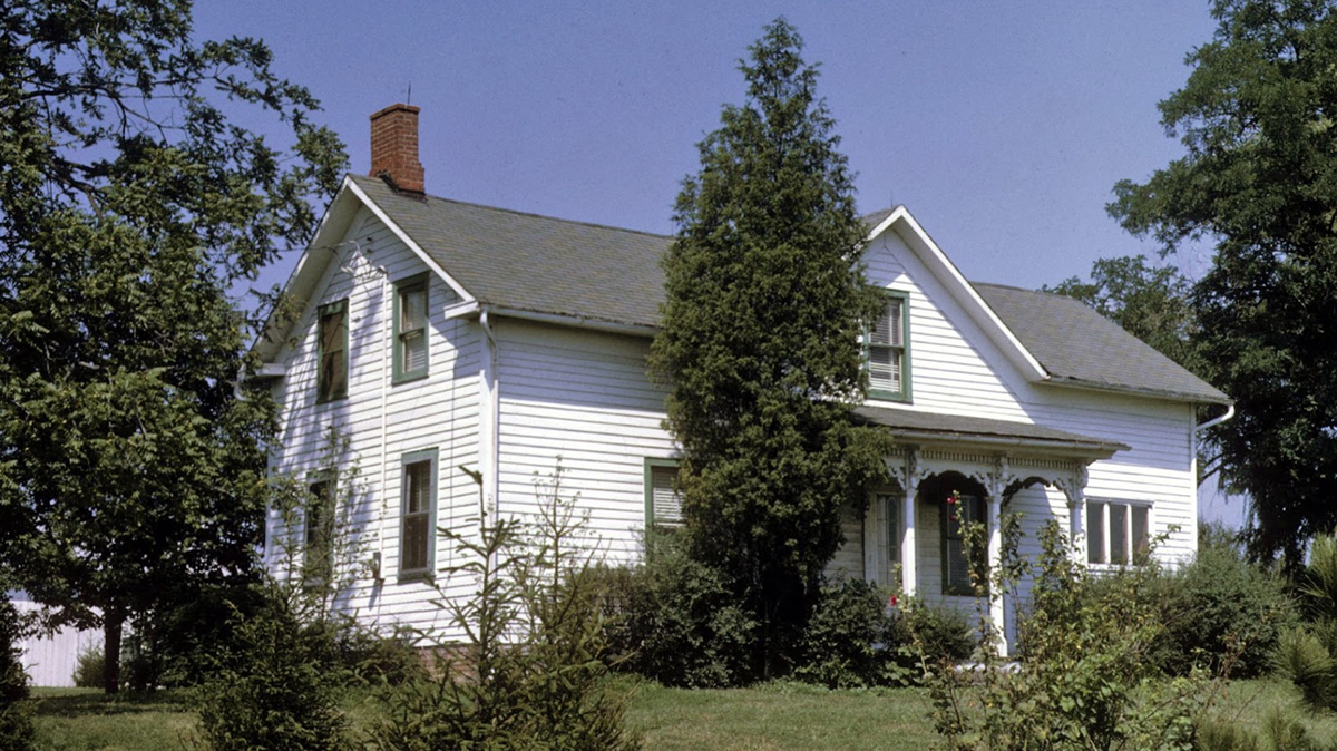
In April 1965, Metro Parks acquired a 1.85-acre parcel of land on Schrock Road from the Krebs family, which included a 150-year-old farmhouse. The farmhouse was remodeled and also became a conference center with living and sleeping accommodation. Known as Willowhaven Conference Center, it became available for advance reservation by similar environmental groups from October 1967. The meeting rooms at the Willowhaven Conference Center would also be used by park naturalists for public programs. It operated successfully for a number of years, but structural problems with the building eventually made upkeep of the center economically unviable. The building was torn down in the 1980s.
THE PARK OPENS
In October 1968, Sharon Woods Metro Park officially opened as the fourth park in the Columbus & Franklin County Metropolitan Park System. An entrance was built on Cleveland Avenue, on the east side of the park, and the entry road, about 1.3 miles long, went into the park as far as Schrock Lake. (Much later, in 1993, this main entrance to the park was moved slightly north of its original location, and had the advantage for visitors of being controlled by traffic signals on a very busy road). Parking was provided for 144 vehicles. The road was graded and had a base course asphalt layer by the time of the opening. A final surface coat was added to the entry road the following year.
Ready for the opening, a 10-acre picnic area was built, featuring 30 picnic tables and 12 grills (it is now known as the Maple Grove Picnic Area), with numerous pieces of play equipment, including swings. Two deep wells provided clean drinking water. Around 500 Scotch pine and spruce trees were planted throughout the picnic area, to provide screening for users.
A second family picnic area (later to be known as the Schrock Lake Picnic Area) was opened within a couple of years, with tables and grills near Schrock Lake. The popularity of picnicking had been well established at the first three Metro Parks. By the mid-1970s, the third family picnic area at Sharon Woods (later called the Apple Ridge Picnic Area) was also opened to the public.
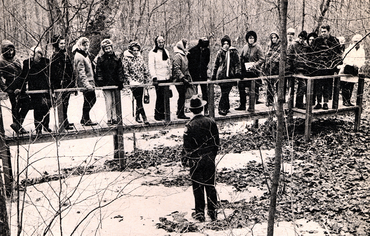
There were two nature trails, both about a mile long, one of them west of Schrock Lake, and the second a little northeast of the lake. More than a thousand trees and shrubs were planted overall in the park, as part of an initial reforestation and landscaping program. Trees included pin oaks, red oaks, maples and sycamores, with attractive shrubs such as blackhaw viburnum and various species of dogwoods. Trees were planted on the park boundary too, especially along Cleveland Avenue and Schrock Road, to provide a dampening effect on the noise from the surrounding traffic lanes.
FISHING
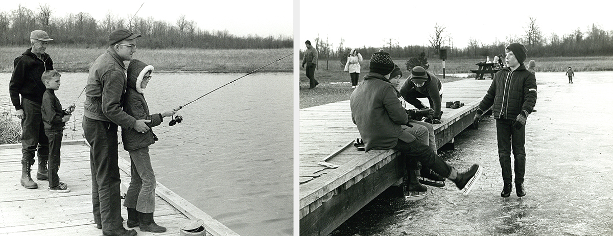
In 1969, the first of three fishing decks was opened on Schrock Lake, for kids age 15 and under to fish. Made from heavy oak, the fishing deck was 110 feet long and 12 feet wide. It stood 18 inches above the water, which was just two feet deep at the edge, but deepened to 8 feet within casting distance. The lake had been stocked with fish in 1966, as the foundation of an aquatic ecosystem that would attract shore birds, wading birds and waterfowl. Fish included largemouth bass, channel catfish and bluegills.
A second deck of the same type was opened a year later, followed by a fishing pier, built of concrete, all of them on the southern shore of the lake. Fishing from all three decks was restricted to children aged 15 and younger. The restriction was geared towards providing adequate resources to encourage young anglers to take up a rapidly growing pastime, without threatening to deplete fish stocks. Over the years, the success of the lake as a self-sustaining aquatic system led to the restriction being eased. In 2001, seniors were also allowed to fish, and since 2017 fishing on Schrock Lake has been open to all ages. Clean water and nutrients ease into the lake continually from a swamp forest to the west, transported in rivulets swollen by spring rains.
ICE SKATING
Schrock Lake would freeze over in the harshest winters. In the early 1970s, Metro Parks allowed ice skaters to use the frozen lake and much fun was had by all! But some voices were raised about safety concerns. The depth of the lake was enough to justify a cautionary approach, and ice skating on Schrock Lake was eventually prohibited. Two much shallower bodies of water, one at Blendon Woods Metro Park and the other at Battelle Darby Creek Metro Park, were later dedicated as ice skating ponds. Only a few inches deep, these ponds would freeze much more reliably and safety was greatly enhanced.
SLEDDING
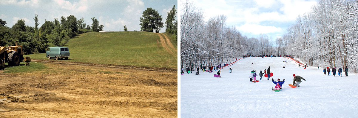
But if the kibosh was put on one winter activity, another would take its place. In 1972 Metro Parks built a 100-foot-high sledding hill at Sharon Woods, with a 500-foot slope. A separate park entrance was created north of the main park entrance, on Cleveland Avenue, to give direct access to the sledding hill. The sledding hill entrance is gated and kept locked except when weather conditions are right for sledding.
CENTRAL OHIO’S FINEST AND SAFEST RECREATIONAL BIKE TRAIL
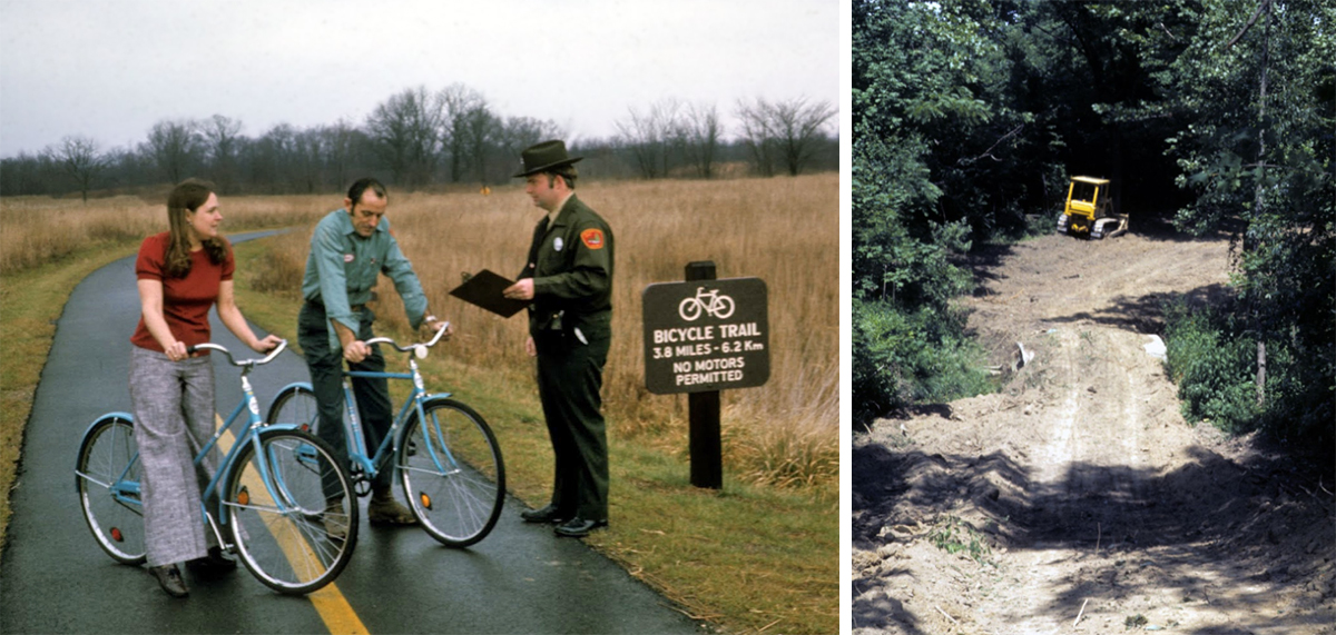
In 1974, Metro Parks began excavations to build a 3.8-mile bicycle trail running around the periphery of Sharon Woods and passing through numerous beautiful wooded areas and open fields. The 8-foot-wide bike trail was completed by the end of the year. Metro Parks’ Director, Ed Hutchins, proudly declared it to be “the finest and safest recreational bike trail in central Ohio.” Featuring a smooth, paved surface, the bike trail featured two steep gradients and crossed over two 60-foot bridges built over stunning ravine scenery. (In 1991, as part of a major trail improvement, the entire 3.8-mile bike trail was widened from 8 feet to 10 feet.)
GETTING THERE
Concerns about the safety of bikers “getting” to the park were also addressed, from both north and south. A new, gated entrance to the park was opened on Schrock Road, for pedestrians or bikers only. It led directly to the new bike trail. For bikers who were resident in the Northland area, and other north Columbus areas, the only way to the park’s gated bike entrance was to cross the Schrock Road bridge over I-71, which had no sidewalk. Metro Parks worked with the Northland Community Council and with ODOT (Ohio Department of Transportation) to address the issue. The vehicle lanes were narrowed and a painted line separated a lane for bikers or pedestrians only. Brightly-colored rubber pylons were added to the painted line at intervals.
Cleveland Avenue also lacked sidewalks, so access to the gated entrance for residents of Annehurst and other north Westerville areas was also dangerous. Work had already been planned to widen Cleveland Avenue. Metro Parks worked with the county highway department to build a separate, 5-feet-wide concrete path all the way from the intersection of Cleveland Avenue and West Main Street in the north, down to Schrock Road in the south. The concrete path, about 3,000 feet in length, was separated from the highway by a stone curb.
BIKE RENTALS
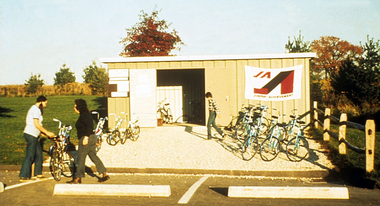
No bike? No problem! In 1975, with the enthusiastic approval of Metro Parks, seven local teenage members of Junior Achievement set up a company called C & L Bike Rental, specifically to rent bikes over the summer to visitors to Sharon Woods interested in using the 3.8-mile bike trail. Junior Achievement is a national non-profit organization, founded in 1919, with a mission to give “young people the knowledge and skills they need to own their economic success, plan for their futures, and make smart academic and economic choices… in the core areas of work readiness, entrepreneurship and financial literacy.”
For the seven C & L Bike Rental entrepreneurs, their 1975 project was an experiment. They invested $2,000 to get started, mostly to acquire fourteen 20-inch-bikes and twenty 26-inch-bikes. The members operated their business out of an aluminum shed close to the trail in the Maple Grove Picnic Area. The 12 foot x 24 foot shed was built by and owned by Metro Parks. The Junior Achievement members staffed it from 3pm to 8:30pm on weekdays and from 11am to 8:30pm on Saturdays and Sundays, and rented their bikes at rates of 75 cents for half an hour up to $2.25 for two hours. They planned to sell off their bikes come September, when all the members would be back in school. They then intended to judge whether the experiment had been a success, and determine whether to continue the experiment the following summer. They were happy with the results, and visitors were happy with their service, so much so that the bike rental business flourished throughout summers for well over a decade.
A METRO PARKS FIRST
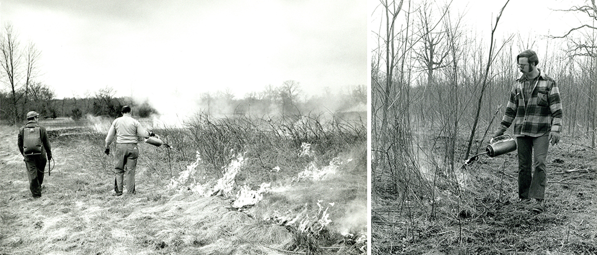
Metro Parks’ resource managers use fire as a tool to manage certain habitats. Known as a prescribed burn, this resource management technique is applied to prairies and savanna habitats in various Metro Parks on a rotating basis. Sharon Woods holds place of honor in having been the first park to host a prescribed burn. The technique was applied to a 15-acre field at Sharon Woods in early April 1974. The controlled burn was conducted by biologists from the Ohio Division of Wildlife, who taught the technique to Metro Parks’ resource management staff.
Prescribed burns destroy invasive plant species and the encroachment of young trees and shrubs from surrounding forest areas, allowing native flowers and grasses to thrive in prairies or meadows. The blackened earth from the fires creates a heating effect that helps seeds to germinate.
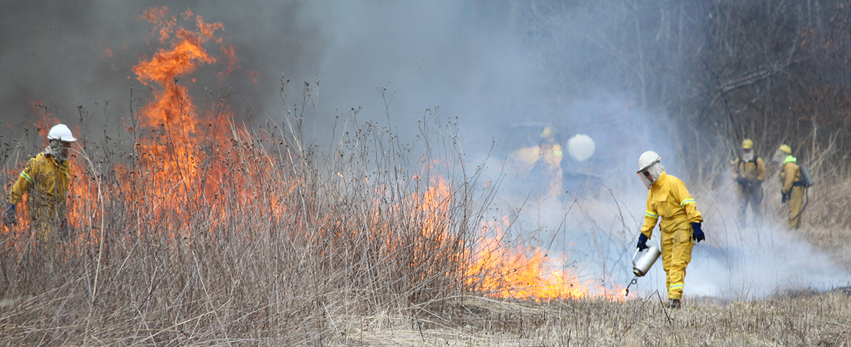
As you’ll see from the first burn photos and from a more recent prescribed burn photo, safety considerations for staff are much more rigorously applied today. Metro Parks acquires permits from the Ohio Division of Forestry, Ohio Environmental Protection Agency and some local fire departments before conducting its prescribed burns. READ MORE ABOUT PRESCRIBED BURNS HERE
THE EDWARD S. THOMAS STATE NATURE PRESERVE
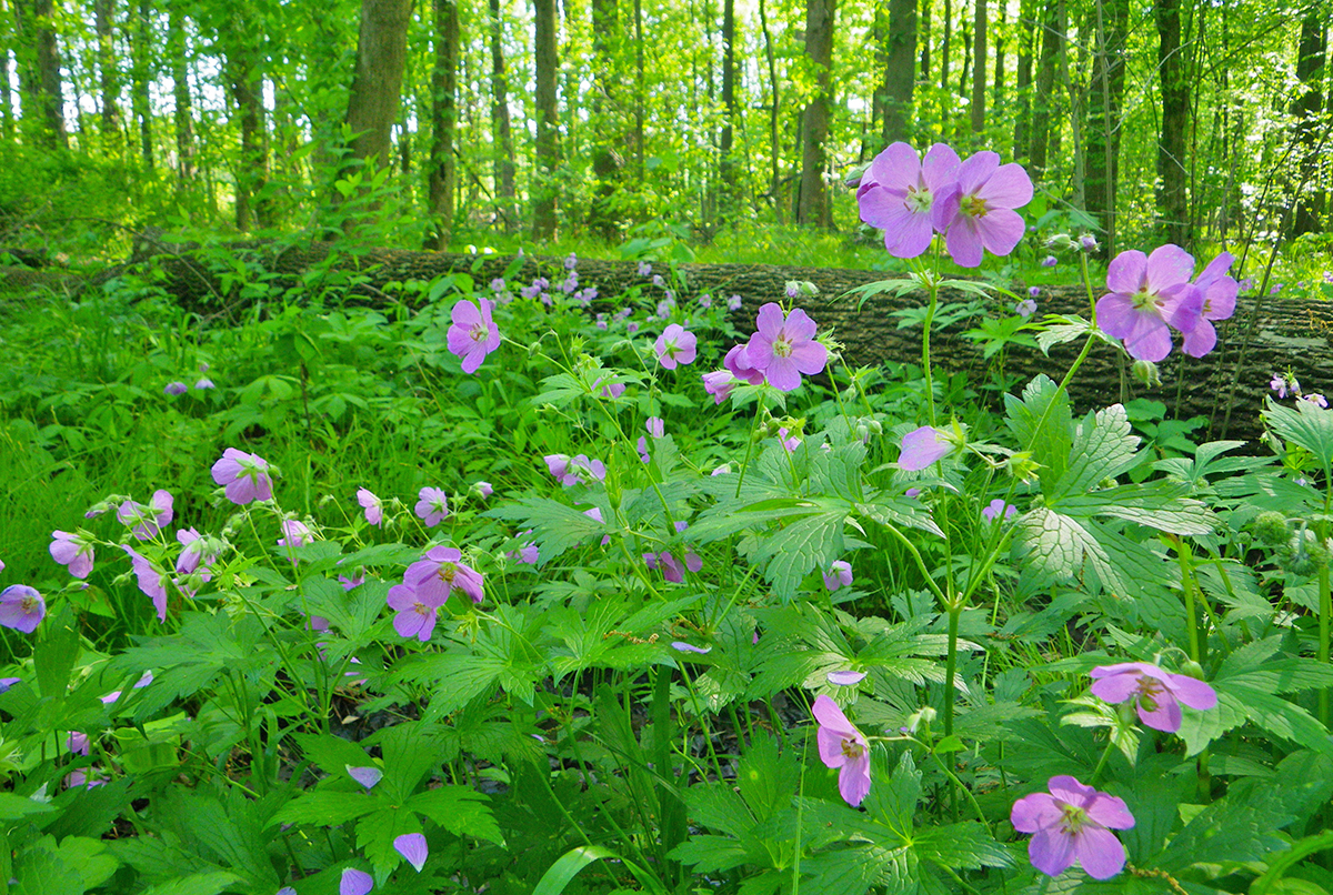
In February 1975, the Metro Parks Board of Commissioners passed a vote to dedicate a 320-acre area of Sharon Woods Metro Park as a state nature preserve, to be named the Edward S. Thomas State Nature Preserve. Ed Thomas was the first chairman of the Metro Parks Board in 1945 and served in that capacity through to 1967. He also wrote a weekly nature column for The Columbus Dispatch and wrote features for the newspaper for more than 50 years, as well as providing the text for the newspaper’s Professor Naturebug cartoon feature. For 31 years he was curator of natural history at the Ohio State Museum’s Department of Natural History. Mr. Thomas said at the time of the dedication, “I can’t think of a place I’d rather have dedicated to me. This particular spot has great diversity of habitats.”
Those habitats included prairie-type herb communities of old fields, oak-hickory and beech-maple woodlands, the swamp forest west of Schrock Lake, river bottom ravines and several small ponds of possible glacial origin. An extremely rare insect, the earwig scorpionfly, had been found there just a couple of years earlier, only the second recorded occurrence of this species in Ohio.
The state nature preserve system, administered by the Ohio Department of Natural Resources, protects natural areas from future developments that might ruin their unspoiled character. That protection from developments such as highway and utilities projects, inappropriate recreational facilities, and harvesting of timber, accorded truly well with Ed Thomas’s naturalist values. He said, “These are supposed to be wilderness parks for people who really appreciate the outdoors. I am not in favor of putting hundreds of thousands of people in the parks. They are better if not crowded because the people out there then are the ones who really appreciate them.”
The Edward S. Thomas State Nature Preserve covers almost the entire western half of Sharon Woods. In accordance with the guiding principles of the 1970 Natural Areas Law, Metro Parks committed to maintain the natural character of the area, which means there would be no picnic facilities or playgrounds in the area, and no off-trail activities would be allowed there. The beauty of the area can be appreciated by visitors by using the 3.8-mile Multipurpose Trail, part of which passes through the nature preserve, or the 1.1-mile nature trail west of Schrock Lake, subsequently named the Edward S. Thomas Trail.
The Edward S. Thomas State Nature Preserve became the third such preserve in the Metropolitan Park System, following the dedications of preserves at Blacklick Woods and Highbanks. Two more state nature preserves were dedicated later, in Clear Creek and Pickerington Ponds Metro Parks. In 2022, the state nature preserves at Sharon Woods, Blacklick Woods and Highbanks were also inducted into the national Old-Growth Forest Network.
A DEER PROBLEM
White-tailed deer are the state mammal of Ohio. One of the most thrilling sights a visitor might see on a visit to a Metro Park is coming across a large antlered buck in a forest clearing, or discovering a doe and her fawns off a meadowed trail. Photographers invest hundreds, or even thousands of dollars, on lenses and equipment to help them capture these sights in perpetuity in digital form (rarely now on film).
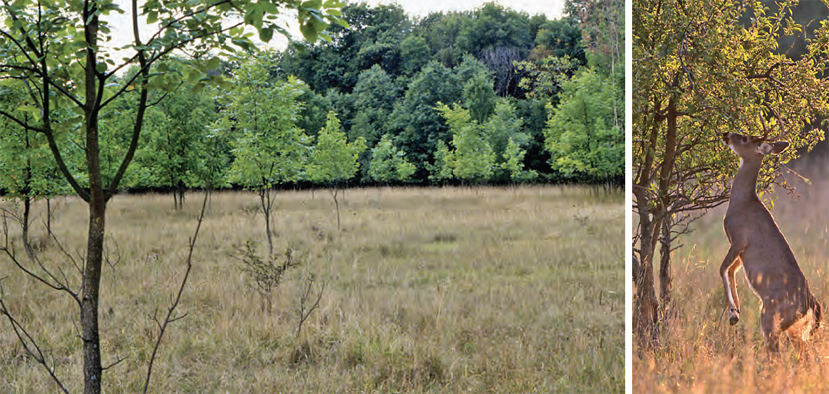
A healthy, and well-managed deer population is necessary to allow these kind of gratifying interactions in parks. Equally so, a healthy, and well-managed deer population is essential to allow parks themselves to thrive. Of all the challenges facing Metro Parks resource managers, that of deer management became the greatest and most disheartening, and Sharon Woods found itself at the very heart of the problem in the early 1990s.
An over-abundant deer population can cause devastation to areas it inhabits, and eventually will severely damage the health of the deer herd itself. This happened at Sharon Woods. Biologists advise that any particular square mile of natural area can harbor about 20 to 30 white-tailed deer without damage to the ecosystem. There were no deer in Sharon Woods when the park opened in 1968. Indeed, there were no white-tailed deer recorded in any of the Metro Parks until the mid-1970s. But by the early 1990s, about 500 deer were recorded as present within the 1.2 square miles of Sharon Woods Metro Park. The damage to the ecosystem of the park was massive and potentially irrecoverable. A 6-foot browse line had emerged throughout all the forested areas of the park. Deer will stand on their back legs to browse, if necessary, and by doing so can reach vegetation about 6 feet above ground. They are voracious browsers and eat about 450 species of plants.
THE DEVASTATION
With a deer herd so greatly in excess of a sustainable limit, the habitats of Sharon Woods suffered the consequences. “From a height of six feet down, there was nothing but deer and pawpaws, a native plant they don´t like. They ate everything else, even the bark off the trees,” said Metro Parks Deputy Director about the problem in Sharon Woods at the start of the 1990s.
Wildflowers, which had become one of the great attractions for park visitors, vanished completely. More than 250 plant species in the forest understory were gone. The survival of numerous small mammals and ground-nesting birds, which relied on that habitat, was severely threatened and they, too, disappeared from the park.
Although Sharon Woods had been the most severely impacted by an over abundance of deer, other Metro Parks suffered too. Indeed, the problem wasn’t restricted to central Ohio. Cleveland Metroparks faced similar problems, and reported that woodland asters, goldenrods and rarer species such as trillium and fringed gentian were in serious decline, that sumacs, stripped of their bark by hungry deer, were rapidly disappearing; and that jewelweed, an important food for small birds and mammals, was virtually gone.
As well as damage to the environment, vehicle collisions with deer, both inside and outside of parks, were on a significant rise. There were so many deer at Sharon Woods that Park Rangers had to direct traffic on weekday evenings to protect people as well as deer. The health of the deer herd was also in decline. Overbrowsing led to a depletion of food for the increasing deer herd, and consequent loss of nourishment. Many deer were found to be under-nourished or unhealthy. A new, deer management program was needed – to save the deer, and to save the park
RECOVERY

The natural habitats at Sharon Woods have recovered, the small mammals and birds that relied on these habitats are back, and the deer herd at the park is healthy and sustainable. But this didn’t come easily, or quickly. Resource Managers at Metro Parks were under no illusions. If there was a fix, at all, for the habitat destruction associated with the deer problem at Sharon Woods, it would not be a quick fix.
Consultations with wildlife biologists tended to emphasize culling as the only fully reliable solution for the long-term recovery of the park and the deer herd. Recognizing that this would be an emotive issue for many members of the public, Metro Parks committed itself to wider consultations with the community, and found itself bombarded with alternative suggestions. Many of these were tried, but were not successful.
BIRTH CONTROL
These options included birth control methods. As early as 1989, Metro Parks worked with a local veterinarian to administer a prostaglandin drug, called Bovilene, which had been developed to prevent reproduction in cattle at feedlots. A more reliable form of birth control emerged in the early 1990s, when Metro Parks worked with the Humane Society of the United States to develop a deer birth control program using a drug developed by the society to control populations of wild horses that were expanding unsustainably on islands off the coast of Virginia. The society had experimented with the drug on white-tailed deer on Fire Island, New York.
Metro Parks included 27 does in the program at Sharon Woods, starting in 1995. The program required each doe to be injected twice, with annual booster shots, of the immuno-contraceptive, Porcine Zona Pellucida (PZP). The does were ear-tagged with numbers for identification and monitoring purposes. The program continued for eight years, and ceased in 2003 when the Ohio Division of Wildlife refused to continue issuing an annual permit for the use of the drug. It is estimated that about 184 births were prevented at Sharon Woods over the eight-year-period of the program. That’s a potential reduction of about 23 deer per year in a herd that was already many times beyond that number in terms of a sustainable capacity.
DEER RELOCATION
Another suggestion was the relocation of deer out of Sharon Woods (and also out of Highbanks, Blacklick Woods and Inniswood Metro Gardens). Although this option had been discounted by Metro Parks, initially, for the high financial cost and a projected high mortality rate for the transported deer, nevertheless the park district bowed to public pressure and inaugurated a trial program, in collaboration with the Ohio Division of Wildlife.
A number of specially licensed wildlife propagators were chosen to trial the program of relocations in the winter of 1993-94. A total of 500 deer were removed from the four parks, but the fear of high mortality rates proved well-founded, partly from the stress experienced by captured and transported animals, partly from dangers inherent in the procedure. An analysis of the mortality rate led to the Ohio Division of Wildlife banning the relocation of white-tailed deer from any public property in Ohio.
EXCLOSURES
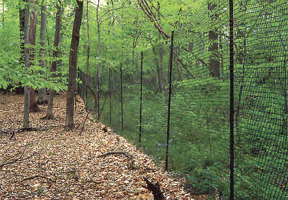
High chain link fences were also erected at numerous parks to create exclosures, a stopgap process designed to protect the native plants from browsing and allow an earlier recovery of native habitats, and an earlier return to the park for the smaller mammals, grassland birds and butterflies and insects that relied on those habitats.
A SAD NECESSITY
But the main component of Metro Parks’ deer management program, since 1994, has been—and has had to be—the humane culling of deer. Commissioned park officers, trained in the use of firearms, work at night from late-October onward, covering 10 different Metro Parks over the course of the winter. The culled deer are delivered to processors licenced by the Ohio Department of Agriculture Meat Industry, and venison is then donated to the Mid-Ohio Food Bank to help feed the hungry in central Ohio.
SHARON WOODS TODAY
The devastation caused by overbrowsing of the woodland vegetation by deer is now a distant memory. Although surrounded on all sides either by freeways or extensive development, so that external sounds can sometimes intrude into the park, nonetheless the forests are quiet except for the sounds of nature. The woodlands and forest edges provide habitat for countless bird species, insects and mammals, including a now healthy and sustainable deer herd.
This oasis of nature in the heavily-developed Westerville area has close to a million visitors per year. Overall, there are 7 miles of trails in Sharon Woods. One of the original 1-mile nature trails is still there, and was named the Edward S. Thomas Trail, as it loops through the state nature preserve dedicated to Mr. Thomas. The other nature trail has been modified and extended, to become the 1.8-mile Spring Creek Trail, which crosses the creek in two places. This trail was designated as a pet trail in 2017. The Lake Trail, created from paths around the eastern and southwestern sections of Schrock Lake, was also designated as a pet trail the same year. Leashed dogs and cats are also allowed in picnic areas and on park roadways.
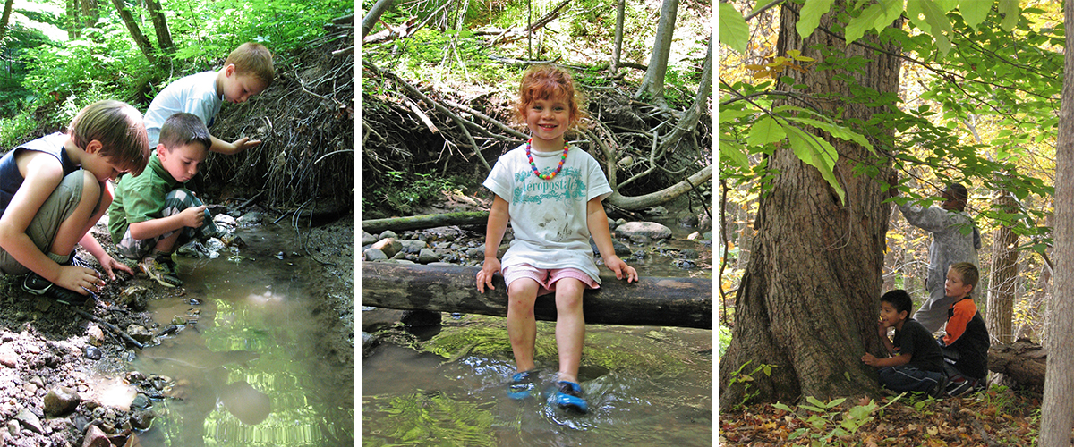
The three picnic areas at Sharon Woods all now have open shelters as well as separate picnic tables. The Schrock Lake Picnic Area features two shelters that each seat 64 people, while the Maple Grove Picnic Area and the Apple Ridge Picnic areas each have one open shelter with the same capacity. The Apple Ridge Picnic Area is located within the bounds of the original nature trail that became the extended Spring Creek Trail. A 7.5-acre natural play area, where visitors can play off-trail in the forest and in the creek, lies just to the north of the Apple Ridge Picnic Area.
The park also has a reservable lodge, Spring Hollow Lodge (the former Outdoor Education facility). It features central heating or cooling, a large meeting room, lounge, kitchenette, and restrooms, with a capacity for 64 people.
I’ve enjoyed Sharon Woods for quite a while. I mostly enjoyed riding my bike around the beautiful trails. Excellent article on Sharon Woods learning about it’s history.
Thank you, that was a wonderful and thorough article to read about Sharon Woods. It was the first Metro park I ever visited, and have frequented it often over the years. I read many books there as a high school student in need of a calming reading space!
Love to hike the 1.8 mi loop and bike the 3.8 perimeter loop except for those big hills! Please repave the southern side where you make the turn east on the long descent towards the entrance. Very bumpy and hard on equipment. Love having the park that I can ride to from the Metzger Park area of Annehurst. Nice history writeup too!
Sharon Woods is one of my favorite parks, a place for fun or quiet contemplation. Thanks for the interesting article